
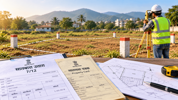
7/12 Extract, Property Card & Land Survey in Maharashtra
7/12 Extract, Property Card & Land Survey: Why Your Documents May Not Match the Ground Reality
You have a 7/12 extract. The seller has shown you a property card. The survey number appears correct. Everything seems fine—until you visit the actual land.
The boundary is somewhere else. An old compound wall does not appear to follow the plot. The site seems smaller than expected. Or the neighbouring property appears to occupy part of the area.
This situation can be confusing, but it does not necessarily mean that a land record is “wrong.” Land records and physical site conditions serve different purposes, and changes, subdivisions, old measurements, occupation and boundary markers can create differences that need to be investigated.
That is where a professional land survey becomes useful.
What Is a 7/12 Extract?
The 7/12 extract is an important land record used in Maharashtra, particularly for land recorded through the survey/Gat-number system.
The Maharashtra Land Records Department provides 7/12, 8A, Ferfar and other land-record services through the Mahabhumi portal. Digitally signed versions are available for official and legal use, while the ordinary online viewing facility is intended for viewing rather than official/legal use.
A 7/12 can contain information relating to the land and recorded holders and other rights or entries. However, simply reading the area mentioned in a 7/12 does not tell you everything about the physical condition of the site.
For example, it does not mean you should assume that an old fence automatically represents the exact boundary shown in the record.
What Is a Property Card?
A Property Card (Malmatta Patrak) is another land record used in Maharashtra, particularly in areas covered by city-survey/property-card systems.
The Maharashtra Land Records Department provides digitally signed Property Cards and related services through Mahabhumi. The department’s city-survey information explains that property cards are maintained for properties within city-survey areas.
Property Card and 7/12 are therefore not simply two names for the same document.
The applicable record depends on the nature and location of the property.
Why Can Documents and Ground Reality Look Different?
This is the question most property owners actually want answered.
There are several possible reasons.
1. Old Boundary Markers
A property may have an old wall, fence, trees, stones or other physical markers that have existed for years.
But the existence of a physical marker does not automatically prove that it represents the recorded boundary.
If you are planning construction or purchasing the property, this is something worth checking rather than assuming.
2. Subdivision of Land
A larger survey or Gat number may have multiple holders or portions.
The Maharashtra Land Records Department describes pot-hissa measurement as a process used when multiple holders share a survey/Gat number and their respective areas and maps need to be separated.
This is one reason a buyer should understand the specific portion being purchased rather than looking only at the larger survey number.
3. Changes Over Time
Land can change significantly over the years.
A property may have been:
- Subdivided
- Fenced
- Developed
- Combined with adjoining land
- Affected by road or development work
- Transferred between owners
- Subject to mutation entries
The records may also contain historical entries that need to be understood in context.
4. Measurement and Physical Occupation Are Different Questions
A document may state an area, while a survey on the ground deals with the physical location, dimensions and relationship between boundary points.
This is why looking only at the area figure is not always enough.
Imagine a plot recorded as a particular area but with an irregular shape. Two plots can have similar areas while having very different dimensions and usable layouts.
For construction, those physical differences can matter considerably.
What Does a Land Survey Add?
A professional land survey brings the records and physical site into the same discussion.
Depending on the purpose of the work, a survey can help examine:
- Site dimensions
- Boundary points
- Plot shape
- Existing physical features
- Relative position of adjoining properties
- Survey/Gat or property identification
- Available survey maps
- Ground levels, where relevant
- Construction or layout requirements
The Maharashtra Land Records Department also provides Bhu Naksha, where survey-number maps can show boundaries, area and neighbouring survey information. The department states that land maps and 7/12 records are integrated through its mapping services.
A professional survey can therefore be particularly useful when the map, documents and site need to be understood together.
A Simple Example
Suppose you are buying a plot in Palghar.
The seller shows you the 7/12 extract and points to an existing fence, saying:
“This is the boundary.”
You visit the site and notice that the fence does not appear to match the dimensions shown in the available plan.
Instead of relying on visual judgment, this is the point where you should stop and investigate.
A survey professional can examine the available information and carry out the appropriate site measurements.
If the matter requires formal land-record measurement or demarcation, the government process should also be considered.
What If There Is a Boundary Dispute?
A private survey should not automatically be treated as an official determination of a disputed land boundary.
Maharashtra’s e-Mojni system allows citizens to apply for land measurement and provides information about measurement cases. The official system is operated by the Land Records Department and is specifically designed to manage land-measurement applications.
So, if two neighbouring owners disagree about a boundary, the correct procedure depends on the nature of the issue.
A professional surveyor can help identify the technical surveying requirement, while official land-record procedures or appropriate legal advice may be required for formal disputes.
When Should You Get a Land Survey?
Consider professional surveying before taking major action when:
Before Buying Land
If the plot’s physical dimensions, boundary or subdivision are unclear, investigate before completing the transaction.
Before Construction
Accurate site information can help architects, engineers and contractors work from reliable ground conditions.
Before Building a Compound Wall
Do not assume that an existing fence or neighbour’s wall is the correct boundary.
Before Subdivision
If a portion of a larger property is being separated, accurate measurement becomes particularly important.
When Documents Appear Different
If the area, shape, boundary or location shown in the available records does not seem to match the site, investigate the difference.
What Should Property Owners Check?
Before arranging a survey, keep whatever relevant records are available, such as:
- 7/12 extract
- Property Card, where applicable
- 8A extract
- Ferfar/mutation records
- Sale deed or previous documents
- Existing survey maps
- Layout plans
- Previous measurement documents
The exact documents required will depend on the property and purpose of the survey.
Also remember that a land survey is not a substitute for legal title due diligence. Ownership, encumbrances, litigation and other legal matters should be checked through the appropriate legal and official channels.
Practical Tip
Never use a single document—or an old boundary wall—as the only basis for deciding where a property physically begins and ends.
Look at the records, understand the applicable survey information and inspect the actual site.
If something does not appear to match, investigate it before construction, fencing, purchase or sale.
Land Survey Services in Maharashtra
For property owners and developers in Virar, Vasai, Nalasopara, Palghar, Dahanu, Badlapur, Khopoli, Mumbai and other areas of Maharashtra, professional surveying can help when accurate site information is required.
Shradha Land Surveyors provides land survey, land measurement, boundary survey, demarcation, engineering survey, contour survey, construction survey and related surveying services.
With around 20 years of surveying experience, the team can assess your requirement and help determine what type of survey is appropriate for your property.
Call: 09850264720
When your documents and the ground do not appear to tell the same story, do not guess. Measure, compare and investigate before taking the next property decision.